The Taklamakan Desert in 10 Questions — How a Sea of Sand Formed in Inner Asia
Where is the Taklamakan, why is it so dry, where does its sand come from and why did Silk Road traders avoid it? Ten short answers with diagrams.
The Taklamakan is one of the driest places in Asia and one of the biggest sand deserts in the world. Here are the questions students ask most often about it — answered briefly, with the geography behind each answer.
1. Where is the Taklamakan?
It sits in the Tarim Basin in northwest China, deep in the middle of the Eurasian continent. The basin is shaped like an oval bowl. High ranges rise on three sides of it: the Kunlun in the south, the Pamirs in the west and the Tian Shan in the north. On the eastern side the land stays low and dry, running out towards the salt flats of Lop Nur.
2. How big is it?
Estimates differ, because it depends where you draw the edge of the sand. Most sources give roughly 300,000 km² — larger than the whole United Kingdom.
3. Is it the largest sand desert on Earth?
No — it is the second-largest sea of sand. First place goes to the Rub’ al Khali (“Empty Quarter”) on the Arabian Peninsula, which covers about 650,000 km², mostly in south-eastern Saudi Arabia.
A “sea of sand” (an erg) is unusual: only about 20% of the world’s deserts are sandy. Most are gravel plains, bare rock or dry mountains.
4. How dry is it?
Very. Geographers call a region a desert when it gets under 250 mm of rain or snow in a year. The centre of the Taklamakan gets under 10 mm — less than a twenty-fifth of that limit.
5. Why is it so dry?
Two reasons work together.
Reason one — a rain shadow. Moist air blowing towards a mountain range has to climb over it. Rising air cools; cool air cannot hold as much water vapour, so clouds form and the water falls as rain or snow on the side facing the wind (the windward side). The air that comes down the other side (the leeward side) is dry and warms as it sinks. The mountains around the Tarim Basin catch nearly all the moisture from the Asian monsoon in the south and from storms in the north.
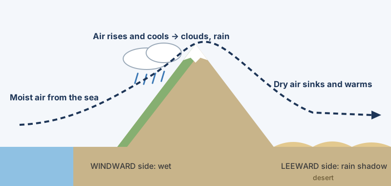 How a rain shadow works. Diagram: Landform Atlas.
Reason two — distance from the sea. The basin is among the places on Earth farthest from any ocean. By the time air reaches it, most of its moisture has already fallen somewhere else. Deserts like this are called interior (or continental) deserts. The Taklamakan is both kinds at once.
6. Where does all the sand come from?
Not from the desert itself. Studies of the minerals in the sand show that it was worn off the Kunlun and Pamir mountains and carried down into the basin by rivers and ice. The wind then reshaped it into dunes.
This only became possible once the mountains around the basin had been pushed up by plate movements, millions of years ago. How many millions is still debated by scientists.
7. Do the dunes move?
Yes. About 85% of the Taklamakan is shifting dunes, and some are 200–300 m tall. Wind lifts sand grains and drops them a little further on, in short jumps called saltation. The grains climb the gentle side of the dune facing the wind and pile up at the crest until they slide down the steep far side, called the slip face. As grains keep leaving one side and arriving on the other, the whole dune creeps downwind.
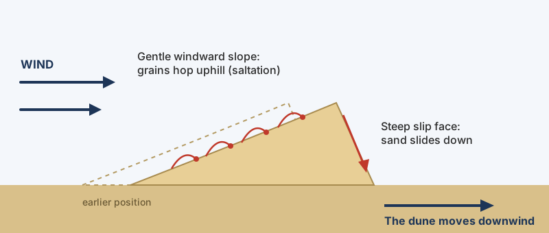 Why dunes travel. Diagram: Landform Atlas.
The wind also lifts fine dust. In spring, dust from the basin can rise around 10 km high and drift east across China and over the Pacific.
8. Does anything live there?
Around the edge, yes. Snow and glaciers in the mountains melt every summer, and rivers carry the meltwater down into the basin. The Hotan River flows north into the desert only in the warm months; in winter its bed is dry. Where rivers leave the mountains they slow down and spread fertile sediment into alluvial fans, with groundwater beneath — perfect places for oases. Along the Tarim River, poplar forests line a green strip roughly 500 km long.
The Tarim itself never reaches the sea. It runs along the desert and ends near Lop Nur. A basin with no outlet to the ocean is called an endorheic basin.
9. Why did the Silk Road go around it?
Because water was only found at the foot of the mountains. Caravans travelled from oasis to oasis around the rim instead of crossing the dunes. From Dunhuang in the east, one route followed the Tian Shan in the north (through towns such as Turpan and Kucha) and another followed the Kunlun in the south (through Miran, Niya and Khotan). The two met again at Kashgar.
UNESCO listed one section, the Chang’an–Tianshan Corridor, as a World Heritage Site in 2014 — about 5,000 km of routes in use from the 2nd century BC to the 16th century AD.
10. What does “Taklamakan” mean?
Nobody is completely sure. Makan is an Arabic word for “place”. The meaning of takla is disputed. The popular translation “the place you go into but never come out of” is a folk explanation, not a proven origin.
A lesson from Lop Nur
The lake at the end of the Tarim, Lop Nur, covered about 3,100 km² in 1928 but later dried up as more river water was dammed and used upstream. One 2017 study suggests that the ancient Silk Road kingdom of Loulan, beside the lake, may also have declined because too much water was taken upstream — not only because of climate. In a desert basin, every drop used upriver is missing downriver.
Quick check
| Question | Answer |
|---|---|
| Which two types of desert is the Taklamakan? | Rain shadow and interior (continental) |
| What happens to air on the windward side of a mountain? | It rises, cools and drops its moisture |
| Where did the sand come from? | Eroded from the Kunlun and Pamir mountains, carried by rivers |
| What is a slip face? | The steep downwind side of a dune, where sand slides down |
| What is an endorheic basin? | A basin whose rivers never reach the sea |
| Why were oases found at the edge? | Mountain meltwater and groundwater collect on the alluvial fans there |
More videos on this topic
Sources
- The Taklimakan Desert: A Factory for Dust Storms — NASA Earth Observatory
- Winter and Summer in the Tarim Basin — NASA Earth Observatory
- Rain shadow — National Geographic Education
- Deserts: Geology and Resources — Desert Features (USGS)
- Rub' al-Khali — Encyclopaedia Britannica
- Silk Roads: the Routes Network of Chang'an-Tianshan Corridor — UNESCO
- Silk Road Trade Routes — University of Washington, Silk Road Seattle
- Rittner et al. (2016), provenance of Taklamakan sand — UCL Discovery
- Lop Nur and the decline of Loulan — Scientific Reports 7, 43102 (2017)